What is it?
Suitability mapping is a method of evaluating land with respect to several spatially-variable inputs, scoring a location according to the combination of inputs superimposed on one another. This technique has traditionally been employed to support decision-making for land use planning; however, it has direct applicability to mineral exploration and development. Prospectivity mapping is an application of suitability mapping where multiple spatially-variable inputs, derived from remote-sensed or field sampled data, are evaluated simultaneously to identify potential values and risks.
Why perform prospectivity mapping?
Prospectivity maps will support better decision-making, getting your team to a decision point more quickly and with greater clarity of the spatial variability of value and risk. As spatial data used for evaluation are commonly not of consistent quality or distribution, locations can be scored in terms of uncertainty in addition to value. Prospectivity mapping can inform data gathering and sampling programs by discerning locations of the known (i.e., locations of high and low modelled value) and the unknown (i.e., locations of poor data quality or density). Finally, by applying consistent evaluation metrics, prospectivity mapping can support ranking of contiguous and discontiguous tenures in exploration or development stages.
How is it done?
Methods vary slightly according to the specific project, but follow a general template:
- Define values and risks
- Identify controlling mechanisms and related spatial factors for each value and risk
- Identify and acquire required input data
- Prepare, interpolate, or derive continuous data to represent spatial factors
- Normalize spatial factors
- Combine inputs with map algebra
- Identify prospective locations
- Publish to Web mapping application or field maps
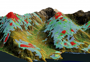
Analysis of a variety of remote-sensed data, including but not limited to:
- Aeromagnetic and gravity imagery analysis to detect subsurface anomalies
- Shortwave infrared (SWIR) and thermal spectrum radiometric analysis to detect epithermal alteration zones
- Visible to near infrared spectrum (NIR) radiometric analysis for vegetation and land cover classification
- Digital elevation model (DEM) analysis for structural lineament detection
- Hydrological analysis for sample provenance interpretation
Data can be acquired from a variety of sources. Low-resolution satellite data can be acquired from free, publicly-available sources (e.g., ASTER, OLI, and Sentinel-2 data), high-resolution satellite imagery can be acquired on-demand from a number of private satellite operators. For the ultimate in high-resolution data, Coastal Resource Mapping can acquire multispectral, SWIR, and magnetometer data with fixed-wing or quadcopter UAVs.
Why choose CRM?
Coastal Resource Mapping provides GIS mapping and geospatial consultancy services to industries across North America. Utilizing cutting-edge GIS software and technology, our GIS consulting team provides viable geospatial mapping solutions and data analysis to help organizations better understand their geographic information and make more informed decisions. If you are looking to:
- Demonstrate value and risk evaluation to potential investors
- Support your decision-making process with value and risk evaluation
- Reach a decision point in a timely and efficient manner
- Receive technical support with data processing, analysis, and visualization
- Acquire proprietary, high-resolution data
Coastal Resource Mapping has you covered. Backed by over 20 years of experience, our knowledgeable and highly diverse team, inlcuding professional geoscientists, UAV operators, spatial analysts, and developers, provides hassle-free and innovative solutions tailored to your geospatial needs.
Some of the key benefits include:
- Volumetric computations
- Track of equipment locations
- Environmental compliance
- Mining operations boundary disputes
- Detecting water leaks and spills
- Vegetation growth management
- Tails assessment and management